Since google maps introduced the terrain maps and I spotted the Tehan Falls I wanted to go there. The Tehan Falls are 60 feet high, which sounds impressive. However, they are hard to reach, and require some serious bushwhacking. The shortest route via Tehan Falls Road is over private property and close to houses, so I never really considered it. So I thought I have to hike 10 miles (one way) or so via Pleasanton Ridge. But recently I discovered that I could enter the northeastern part of the park via the ‘Preserve’ at Laurel Creek Drive.
I figured that after a few weeks of rain there should be enough water in the creeks for the falls.
The route I planned would lead me from the preserve via a ridge north of Gold Creek to the main ridge and then to another side ridge between Gold Creek and Tehan Canyon. From there I would bushwhack to the falls. The route worked, but was more difficult than expected. Also, I should have gone better prepared. I did carry a printout of mytopo maps with me, but I also should have entered the coordinates of important junctions into my GPS unit.
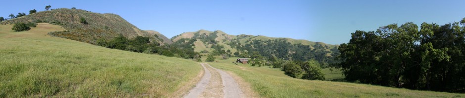
I parked at the parking lot of the preserve at Laurel Creek Road. Behind the restroom house I turned left along the single track trail, over the bridge and along the trail to a small canyon where two creeks join. From there I turned left where the ridge starts. The barely visible trail continues to a fence with missing wiring. From here I turned left on a dirt road which is about 10 feet wide. It was a beautiful trail overgrown with fresh green, but it looked well maintained. The trail went up and down, partially very steep, and featured beautiful views of the valley. Shortly after an X shaped intersection (I went straight) the trail abruptly ends at a gate.

I think this is where the Pleasanton Ridge Park begins. I climbed over the gate. (Note: I am not sure if the whole trip would have been a lot easier had I turned left at the X intersection – on satellite images it looks as if that trail might join the trail on the other ridge, which I only reached after climbing the main ridge. Maybe I should find out another time).
On the other side of the gate the wide trail did not continue, so I had to follow the ridgeline on a barely visible deer trail. The ridge line turned left, and after a short climb lead to a clearing. To follow the ridge, I turned right, following the deer trail. At some points I formed arrows out of branches because I was worried that I wouldn’t find my way back. This turned out to be a good idea.
At some point the ridge ended where it joined the main ridge. This was way steeper than I thought, maybe 60 degrees, and I had to climb it on all four. At the top, the ridge is lined by a fence with a trail on the other side. I walked along the fence and found a spot where the lowest wire was missing (apparently this was well known by the deers because a deer trail lead right to that spot), and crawled under it to the trail. The views from the top where magnificent.

To the east, I could see Pleasanton and Dublin, Mt. Diablo to the north east, and the SF Bay to the west. The trail, as I found out later, was the North Ridge Trail. I followed it south. I knew that at some point it would be joined by another trail leading east onto the other ridge. I found it at trail marker 41, but didn’t recognize it, so I continued further south to trail marker 39, where I finally recognized my mistake.

Back to the correct trail, I had to hop the gate. I followed this trail downhill to a point where it climbed again. According to my topological map, this was the point where I had to start bushwhacking downhill on the southern side of the ridge. I followed a deer trail, first through woods, than a grassy clearing and then chaparral. Again I created markings using sticks. At some point I found a creek bed with almost no water, which I followed to the left (east). Along the way the creek was joined by other creeks, all of them with no water – not a good sign when one is looking for water falls. Further down, after climbing over a few fallen trees which crossed the creek, I could see an old trail along the creek, which I followed until it ended abruptly at a steep cliff: this is where the falls should be, but without water, no falls. The cliff was steep. Lots of fern was growing on top of it. I could imagine that if there was enough water, the falls would be beautiful. However even then, coming from above, I had a bad vantage point, and I couldn’t see an easy way to climb down the cliff.
I took a break, before I headed back to the car, almost exactly along the way that I came. The whole trip lasted just a little bit more than 3 hours. 7.3 miles according to my GPS unit. I could have saved 0.75 miles if I had turned at marker 41 right away instead of going further south.

I just came across this falls on a Top Map. Have you been been back see whe had all the rains in late Dec?
Whats the best way to get there?
Hi Tony,
I did that trip on the same day as I posted it, so that was last Dec 23rd last year. I haven’t been there since.
This is the only way I know to get there. I think there is also a way to get there from Foothill Road, but you have to cross private property very close to houses. That way you approach the falls from below.
A third way *may* be the one I mentioned in the post – turn left at the X shaped crossing. In that case you would join the route in my postt right where the second bushwhacking part begins, and you would approach the falls from above. I will explore that some day.
I run back there all the time! And yes, if you stayed left at the X, it would be significantly shorter (and there is a geocaching bathtub back there 😉 your first picture with the gate is private property, I think. Stay left and you don’t have to jump any fences. As of today, there is a giant eagle’s nest along the trail too.
Thank you. I haven’t updated this post and blog for quite some time, but I did some exploring in that area, and found that route as well (and the bath tub :-)). It’s also a good access to the northern parts of Pleasanton Ridge Park.
In my opinion, Moller Ranch Rd (not the trailhead parking but at the top of the road near the water tower (about 500 yards up the road)) is easier access point. There is a bench early on in the hike that has a view of the whole valley. Another poster left detailed photographs. Take the shorter route to the top. Bring a rope to get up and down to the bottom . If done right 2 hour round trip. However more like 2.5 hours. Don’t wear shorts because of ticks. There is a video of a guy climbing up from bottom. He has talent that I dont.
Just saw comments. You guys are way over cooking it. Moller Ranch Rd is 1 block south on Foothill Rd. If you go up the road you will see designated parking for the local community trails. Go past them 500 yards. There will be a path at the highest point of the road leading to water tower. Just to the right of this paved path is the trail. If you are on the right trail it is steep. You will pass a bench. You will go over the top of the rise where you will have more views of the valley. You then go down to a little wooded area where you then head up. You come up and out of the wooded area to dirt road. Pick up the dirt road for about about 1000 yards. The road is beginning to decend into Tehan Canyon. Another person has posted a picture of where you need to get off the dirt path. The best explanation is the road turns sharply left. Don’t not go that way. Look to the right and you will notice not much but a slight path. This path guides you right to the top. The “path” skirts a steep slope and it is a bit tricky. Wear pants. After about half a mile you arrive at the top. Newt city. To get to the bottom will have to slide down. Good luck getting out. I think a rope is needed to pull oneself out of there. Estimated round trip is 4 miles. Estimated time is 2.5 hours
Creek bed is difficult to traverse and is private property at some point. Also makes hike very physical. Not to mention hundreds of newts. Short route to the top is the much easier and figuring how to get back up
Rob, you are right. I have been there a few times already since I last commented.
I would add to your description that after you leave the first dirt path and turn right, you need to turn left at the next fork (down, not up). Then at the bottom of Tehan Canyon, after you leave the road and follow the canyon, you need to turn right where creek and canyon fork (I took the left fork once – it’s a nice hike, but does not lead to the falls). Following the creek bed is technical.
Another route is to follow the road up at the first fork I mentioned to the top of a hill. If first goes up steep, then down through a wooded area. You can then leave the trail to the left into the canyon, then when you get to the creek follow it downstream. There is an old path along the creek, after a fork. You will then end up at the top of the falls.
I never used the first route I described in that direction, but I used it to return. The falls are disappointing though, even after a big downpour. But it’s a nice adventure.
After I reached the falls from the short route, I went back to try to reach coming up the creek bed. I turned left like you described. I couldn’t figure out how I went so far and did not reach the falls. I poured over the map and realized I must have veered left because I came up on the left side. I don’t plan on returning unless it pours for a couple weeks. It is draining a small area. Even in the drought it was wet at the bottom. So of the YouTube videos show it going pretty strong. It is more steep then photos indicate. Hard to stand near bottom. Are there always so many newts? There were hundreds of them